Ademar Andrade
-
Posts
35 -
Joined
-
Last visited
Ademar Andrade's Achievements
")
Newbie (1/14)
6
Reputation
-
These options come from your acars program. Witch do your company use?
-

How to populate route_detais in phpvms_acarsdata table
Ademar Andrade replied to Ademar Andrade's topic in Code Snippets
the file is acars.php located at core/modules/ACARS/ -
How to populate route_detais in phpvms_acarsdata table
Ademar Andrade replied to Ademar Andrade's topic in Code Snippets
ye yes i did! -
How to populate route_detais in phpvms_acarsdata table
Ademar Andrade replied to Ademar Andrade's topic in Code Snippets
Hi FX30HD, Thanks for your attention, i changed ACARMAP.PHP teh code you said. But still not working... Any another idea? Thanks, -
How to populate route_detais in phpvms_acarsdata table
Ademar Andrade replied to Ademar Andrade's topic in Code Snippets
Nothing about how to populate the table... -
I Wanna know the same think... My custom kacars script isn't populating this column and i don't find nothing about that in the forum! #$#$@$%#%&¨*¨(*& Any Help? Thanks!
-
How to populate route_detais in phpvms_acarsdata table
Ademar Andrade replied to Ademar Andrade's topic in Code Snippets
I don't suppose so... "Support Forum Any questions or bug reports go here. Development Help For help and support for the development of addons I'm not with bug or developing an addon... I need a pice of code to populate a table... Please, If you can't help don't aswer...let the admn do this kind of observantion, because they can move this topic if necessary. -
Hi guys, I'm trying to populate the the route_detais in phpvms_acarsdata table. Now im using a custom KACARS by Jeff. But, at this moment, he can't get any new order. Thanks for any help,
-
Hey Justairbus, How are you doing? How did you put the points of the route in your acarsmap? Reggards,
-
Thank you very much for sharing! Nice job!
-
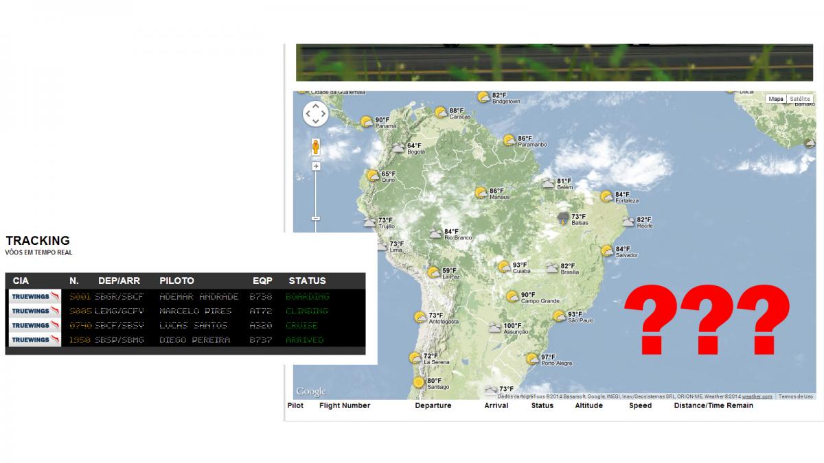
Hi guys, My acars map stoped working. I didn't change anything before stop! This code below was working well!! Any idea? I tried to substitute by originals phpvms files but dindn't work too... We use KACAS 1.0.1.1. ACARSMAP.JS /** * phpVMS - Virtual Airline Administration Software * Copyright (c) 2008 Nabeel Shahzad * For more information, visit www.phpvms.net * Forums: http://www.phpvms.net/forum * Documentation: http://www.phpvms.net/docs * * phpVMS is licenced under the following license: * Creative Commons Attribution Non-commercial Share Alike (by-nc-sa) * View license.txt in the root, or visit http://creativecommons.org/licenses/by-nc-sa/3.0/ * * @author Nabeel Shahzad * @copyright Copyright (c) 2008, Nabeel Shahzad * @link http://www.phpvms.net * @license http://creativecommons.org/licenses/by-nc-sa/3.0/ * * Rewritten for Google Maps v3 */ var flightMarkers = []; var routeMarkers = []; var flightPath = null; var depMarker = null, arrMarker = null; var info_window= null; var run_once = false; var defaultOptions = { autozoom: true, zoom: 4, center: new google.maps.LatLng(-25.363882,131.044922), mapTypeId: google.maps.MapTypeId.TERRAIN, refreshTime: 12000, autorefresh: true }; var options = $.extend({}, defaultOptions, acars_map_defaults); var map = new google.maps.Map(document.getElementById("acarsmap"), options); var weatherLayer = new google.maps.weather.WeatherLayer({ temperatureUnits: google.maps.weather.TemperatureUnit.FAHRENHEIT }); weatherLayer.setMap(map); var cloudLayer = new google.maps.weather.CloudLayer(); cloudLayer.setMap(map); // They clicked the map google.maps.event.addListener(map, 'click', function() { //clearPreviousMarkers(); }); liveRefresh(); if(options.autorefresh == true) { setInterval(function () { liveRefresh(); }, options.refreshTime); } function liveRefresh() { $.ajax({ type: "GET", url: url + "/action.php/acars/data", dataType: "json", cache: false, success: function(data) { populateMap(data); } }); }; function populateMap(data) { clearMap(); $("#pilotlist").html(""); if (data.length == 0) { return false; } var lat, lng; var details, row, pilotlink; var bounds = new google.maps.LatLngBounds(); for (var i = 0; i < data.length; i++) { if(data[i] == null || data[i].lat == null || data[i].lng == null || data[i].lat == "" || data[i].lng == "") { continue; } lat = data[i].lat; lng = data[i].lng; if(i%2 == 0) data[i].trclass = "even"; else data[i].trclass = "odd"; // Pull ze templates! var map_row = tmpl("acars_map_row", {flight: data[i]}); var detailed_bubble = tmpl("acars_map_bubble", {flight: data[i]}); $('#pilotlist').append(map_row); var pos = new google.maps.LatLng(lat, lng); flightMarkers[flightMarkers.length] = new google.maps.Marker({ position: pos, map: map, icon: url+"/lib/images/inair/"+data[i].heading+".png", flightdetails: data[i], infowindow_content: detailed_bubble }); bounds.extend(pos); google.maps.event.addListener(flightMarkers[flightMarkers.length - 1], 'click', function() { clearPreviousMarkers(); var focus_bounds = new google.maps.LatLngBounds(); // Flight details info window info_window = new google.maps.InfoWindow({ content: this.infowindow_content, position: this.position }); info_window.open(map, this); // Add polyline, and start/end points var dep_location = new google.maps.LatLng(this.flightdetails.deplat, this.flightdetails.deplng); var arr_location = new google.maps.LatLng(this.flightdetails.arrlat, this.flightdetails.arrlng); depMarker = new google.maps.Marker({ position: dep_location, map: map, icon: depicon, title: this.flightdetails.depname, zIndex: 100 }); arrMarker = new google.maps.Marker({ position: arr_location, map: map, icon: arricon, title: this.flightdetails.arrname, zIndex: 100 }); // Now the flight path, if it exists var path = new Array(); path[path.length] = dep_location; focus_bounds.extend(dep_location); if(this.flightdetails.route_details.length > 0) { $.each(this.flightdetails.route_details, function(i, nav) { var loc = new google.maps.LatLng(nav.lat, nav.lng); if(nav.type == 3) icon = "icon_vor.png"; else icon = "icon_fix.png"; var navpoint_info = tmpl("navpoint_bubble", {nav: nav}); routeMarkers[routeMarkers.length] = new google.maps.Marker({ position: loc, map: map, icon: url + "/lib/images/"+icon, title: nav.title, zIndex: 100, infowindow_content: navpoint_info }); google.maps.event.addListener(routeMarkers[routeMarkers.length - 1], 'click', function() { info_window = new google.maps.InfoWindow({ content: this.infowindow_content, position: this.position }); info_window.open(map, this); }); path[path.length] = loc; focus_bounds.extend(loc); }); } path[path.length] = arr_location; focus_bounds.extend(this.position); focus_bounds.extend(arr_location); flightPath = new google.maps.Polyline({ path: path, strokeColor: "#FF0000", strokeOpacity: 1.0, strokeWeight: 2 }); map.fitBounds(focus_bounds); flightPath.setMap(map); }); } // If they selected autozoom, only do the zoom first time if(options.autozoom == true && run_once == false) { map.fitBounds(bounds); run_once = true; } } function clearPreviousMarkers() { if(info_window) { info_window.close(); info_window = null; } if(depMarker != null) { depMarker.setMap(null); depMarker = null; } if(arrMarker != null) { arrMarker.setMap(null); arrMarker = null; } if(routeMarkers.length > 0) { for(var i = 0; i < routeMarkers.length; i++) { routeMarkers[i].setMap(null); } } routeMarkers.length = 0; if(flightPath != null) { flightPath.setMap(null); flightPath = null; } } function clearMap() { if(flightMarkers.length > 0) { for(var i = 0; i < flightMarkers.length; i++) { flightMarkers[i].setMap(null); } } flightMarkers.length = 0; if(routeMarkers.length > 0) { for(var i = 0; i < routeMarkers.length; i++) { routeMarkers[i].setMap(null); } } routeMarkers.length = 0; } ACARSMAP.TPL <script type="text/javascript" src="https://maps.googleapis.com/maps/api/js?libraries=weather&sensor=false"> </script> <?php /** * These are some options for the ACARS map, you can change here * * By default, the zoom level and center are ignored, and the map * will try to fit the all the flights in. If you want to manually set * the zoom level and center, set "autozoom" to false. * * You can use these MapTypeId's: * http://code.google.com/apis/maps/documentation/v3/reference.html#MapTypeId * * Change the "TERRAIN" to the "Constant" listed there - they are case-sensitive * * Also, how to style the acars pilot list table. You can use these style selectors: * * table.acarsmap { } * table.acarsmap thead { } * table.acarsmap tbody { } * table.acarsmap tbody tr.even { } * table.acarsmap tbody tr.odd { } */ ?> <script type="text/javascript"> <?php /* These are the settings for the Google map. You can see the Google API reference if you want to add more options. There's two options I've added: autozoom: This will automatically center in on/zoom so all your current flights are visible. If false, then the zoom and center you specify will be used instead refreshTime: Time, in seconds * 1000 to refresh the map. The default is 10000 (10 seconds) */ ?> var acars_map_defaults = { autozoom: true, zoom: 4, center: new google.maps.LatLng("<?php echo Config::Get('MAP_CENTER_LAT'); ?>", "<?php echo Config::Get('MAP_CENTER_LNG'); ?>"), mapTypeId: google.maps.MapTypeId.TERRAIN, refreshTime: 10000 }; </script> <div class="mapcenter" align="center"> <div id="acarsmap" style="width:<?php echo Config::Get('MAP_WIDTH');?>; height: <?php echo Config::Get('MAP_HEIGHT')?>"></div> </div> <?php /* See below for details and columns you can use in this table */ ?> <table border = "0" width="100%" class="acarsmap"> <thead> <tr> <td><b>Pilot</b></td> <td><b>Flight Number</b></td> <td><b>Departure</b></td> <td><b>Arrival</b></td> <td><b>Status</b></td> <td><b>Altitude</b></td> <td><b>Speed</b></td> <td><b>Distance/Time Remain</b></td> </tr> </thead> <tbody id="pilotlist"></tbody> </table> <script type="text/javascript" src="<?php echo fileurl('/lib/js/acarsmap.js');?>"></script> <?php /* This is the template which is used in the table above, for each row. Be careful modifying it. You can simply add/remove columns, combine columns too. Keep each "section" (<%=...%>) intact Variables you can use (what they are is pretty obvious) Variable: Notes: <%=flight.pilotid%> <%=flight.firstname%> <%=flight.lastname%> <%=flight.pilotname%> First and last combined <%=flight.flightnum%> <%=flight.depapt%> Gives the airport name <%=flight.depicao%> <%=flight.arrapt%> Gives the airport name <%=flight.arricao%> <%=flight.phasedetail%> <%=flight.heading%> <%=flight.alt%> <%=flight.gs%> <%=flight.disremaining%> <%=flight.timeremaning%> <%=flight.aircraft%> Gives the registration <%=flight.aircraftname%> Gives the full name <%=flight.client%> FSACARS/Xacars/FSFK, etc <%=flight.trclass%> "even" or "odd" You can also use logic in the templating, if you so choose: http://ejohn.org/blog/javascript-micro-templating/ */ ?> <script type="text/html" id="acars_map_row"> <tr class="<%=flight.trclass%>"> <td><a href="<?php echo url('/profile/view');?>/<%=flight.pilotid%>"><%=flight.pilotid%> - <%=flight.pilotname%></a></td> <td><%=flight.flightnum%></td> <td><%=flight.depicao%></td> <td><%=flight.arricao%></td> <td><%=flight.phasedetail%></td> <td><%=flight.alt%></td> <td><%=flight.gs%></td> <td><%=flight.distremaining%> <?php echo Config::Get('UNITS');?> / <%=flight.timeremaining%></td> </tr> </script> <?php /* This is the template for the little map bubble which pops up when you click on a flight Same principle as above, keep the <%=...%> tags intact. The same variables are available to use here as are available above. */ ?> <script type="text/html" id="acars_map_bubble"> <span style="font-size: 10px; text-align:left; width: 100%" align="left"> <a href="<?php echo url('/profile/view');?>/<%=flight.pilotid%>"><%=flight.pilotid%> - <%=flight.pilotname%></a><br /> <strong>Flight <%=flight.flightnum%></strong> (<%=flight.depicao%> to <%=flight.arricao%>)<br /> <strong>Status: </strong><%=flight.phasedetail%><br /> <strong>Dist/Time Remain: </strong><%=flight.distremaining%> <?php echo Config::Get('UNITS');?> / <%=flight.timeremaining%><br /> </span> </script> <?php /* This is a small template for information about a navpoint popup Variables available: <%=nav.title%> <%=nav.name%> <%=nav.freq%> <%=nav.lat%> <%=nav.lng%> <%=nav.type%> 2=NDB 3=VOR 4=DME 5=FIX 6=TRACK */ ?> <script type="text/html" id="navpoint_bubble"> <span style="font-size: 10px; text-align:left; width: 100%" align="left"> <strong>Name: </strong><%=nav.title%> (<%=nav.name%>)<br /> <strong>Type: </strong> <?php /* Show the type of point */ ?> <% if(nav.type == 2) { %> NDB <% } %> <% if(nav.type == 3) { %> VOR <% } %> <% if(nav.type == 4) { %> DME <% } %> <% if(nav.type == 5) { %> FIX <% } %> <% if(nav.type == 6) { %> TRACK <% } %> <br /> <?php /* Only show frequency if it's not a 0*/ ?> <% if(nav.freq != 0) { %> <strong>Frequency: </strong><%=nav.freq%> <% } %> </span> </script>

-
Hi, Maybe it can help you! http://forum.phpvms....kin/#entry81507 Bye,
-
localconfig.tpl # Google Map Options Config::Set('MAP_WIDTH', '700px'); Config::Set('MAP_HEIGHT', '600px');
-
CLOUDS http://forum.phpvms.net/topic/8559-acars-map-weather-and-clouds/ % FLIGHT COMPLET http://forum.phpvms.net/topic/5394-complete-flight/ That is it. Reggards,
-
Thanks Fernando! I sent you the association of the tables writen by Kairon. I think it will solve our problem. Kind Regards,