-
Posts
81 -
Joined
-
Last visited
-
Days Won
7
Content Type
Profiles
Forums
phpVMS Resources
Downloads
Everything posted by William
-
Apologies if this has come up already. I ran a quick search and could not find any helpful answers. Say we purchased/downloaded the schedule package from a site of the likes of vaschedules.net. Allegedly, they provide the import templates for: Airports (this works) Fleet (this does not work) Schedules (this I don't know yet) So, I thought the aircraft template they used was out of fashion and downloaded the templates pack available in here. I copied all of the values in their rightful spot and tried importing once again to no joy. Same error: "CSV file doesn't seem to match import type" What am I missing? Thanks in advance
-

Help Needed - New unseen issue with registration
William replied to William's topic in Support Forum
Yes, I am afraid as well that may be true. Not that Recaptcha is so efficient anyway..... Great thinking. Thanks 🙂 -
Hello guys, I am running into a situation I have never seen before in PHP VMS (and I have seen quite a bit). Some script is bypassing the Recaptcha at the registration page and consistently registering new pilots at a fairly high rate (like 50 in 15 minutes). If I put the VA in Maintenance mode the issue stops but as soon as I reopen it restarts...... Not sure how to contain this or where to start looking for issues. Any help would be very appreciated so thanks in advance
-
Great, thanks. Kind of like the 3rd and 4th idea option. For the sake of being practical and learn if I were to edit the DB, which one is the correct table to look at? The flight idea can be implemented later once we onboard everyone. Thanks!!
-
OK, I understand. Which would you suggest as the fastest way to do that? I mean, in practice, how would I go about creating a transaction (whether debit or credit)? Really have not understood yet the core logic of this new platform (which seems great however and attracts me) and therefore I am not sure where to start 🙃 As always, I appreciate the time you are taking to help us out.
-
In the old phpvms we had the ability to modify the amount of $$ a pilot had. For instance we could have implemented a sign-up bonus or similar ideas. I cannot see a way for Admin to access the pilot finances or modifying them. Am I missing something? Thanks
-
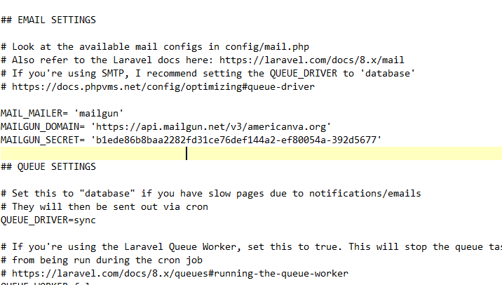
Very valuable lesson learned here!! Clearing the cache was the main culprit. For future reference this is the format that works greatly: MAIL_MAILER=mailgun MAILGUN_DOMAIN='your mailgun registered domain' MAILGUN_SECRET='the long api key here' Want to thank you again for all the help and patience 🙏
-
It's clearly something wrong I am doing - or not doing The cache is a great hint as I was not clearing it after every try, so..... that's a great starting point. I am sure not clearing the cache has made useless many of my attempts. The config you wrote above should work as you say, thanks for writing it down as a confirmation. I will win this battle....😅
-
OK, thanks! I've tried many combinations, but not that one. I will now and report. Mailgun is setup correctly with the zone records modified on the domain..... So that's checked. I know where to get all the API details and keys on their Dashboard..... Checked too. For sure emails are not going out so it's phpvms unable to get them out because I have not configured it well...... Check. Ironically, I cannot make it even if I use the SMTP settings as provided by MailGun.... But I will keep trying....
-
Nope, I wasn't sure.... Just like I wasn't sure about the "Secret" 😃 I copied it from the API interface within Mailgun, they call it API address so I thought..... Well, you already know what I thought Let me try with just americanva.org.......
-
Fantastic article. At the time of me reading this article I believe the module you mentioned above already came out as I saw the ability to create the mentioned separate profiles. The only thing I can add (and that only applies to some extent) is that it could get a bit complicated/time consuming to structure the setup as described when running a major operations including 100s of aircraft with many different configurations like for instance replicating a big airline. Other than that, the explication is perfect and very much appreciated!!
-
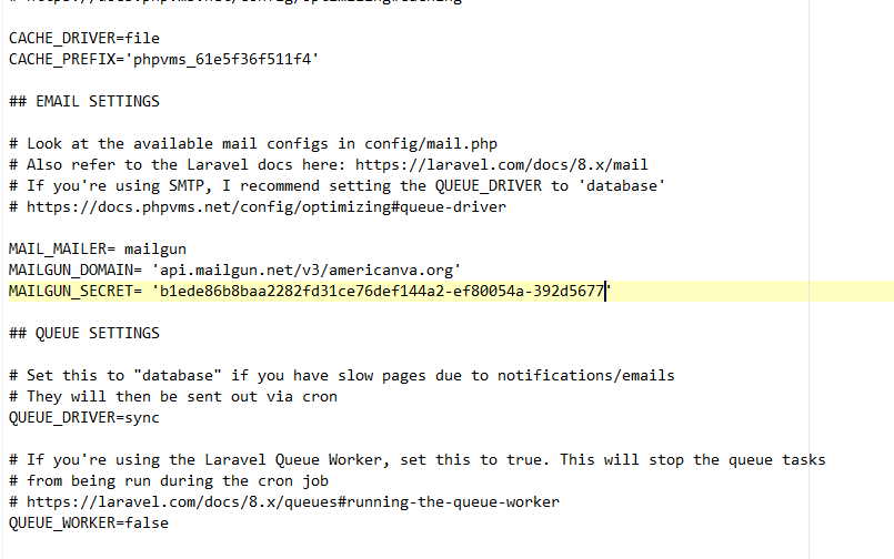
I know I am missing something small somewhere because I'm still getting no joy..... Attached the link for the log where I cannot find error about the mail (Mailgun is not receiving anything either) and the ENV.php screenshot of the config. https://www.dropbox.com/s/1unt7p21nqi13rl/laravel-2022-01-18.log?dl=0
-
Great answer as always, thanks. So the Secret is the API and that clears the concept. I will modify the ENV.php with the mailgun code posted above as per the docs and see where we go from there. To be continued.....
-
Need a bit of help with the email config as well as it does not seem to work properly. I signed up for Mailgun and they gave me 2 options: API or SMTP Couldn't really follow the explanation in the phpvms docs (as I do not know where to find the "Secret" as shown below) [quote] To use Mailgun, set your env.php like: MAIL_MAILER=mailgun MAILGUN_DOMAIN='your mailgun domain' MAILGUN_SECRET='your mailgun secret', [quote] so I choose SMTP and configured the ENV.php as follows: MAIL_MAILER='mailgun' MAIL_FROM_NAME='American Virtual Admin' MAIL_FROM_ADDRESS='admin@americanva.org' MAIL_HOST= 'smtp.mailgun.org' MAIL_PORT='587' MAIL_ENCRYPTION= 'TLS' MAIL_USERNAME= 'postmaster@americanva.org' MAIL_PASSWORD= 'our password' No joy. What am I missing please?
-
Thanks! For now I am just exploring.... If we do end up choosing to move forward, I am sure we will have more than one question and we will interact many times again Cheers
-
That's actually a pretty good suggestion, thanks! Obviously, it worked just fine.... On a side note I also started looking into your work and it's really cool. Really appreciate all you do for the community. We are one of the oldest and largest VA (since 2004) and now evaluating if it may be time to make the switch to phpVMS new version.
-
Been with phpvms since 2010 and testing the water with the new version. Same thing happened here on a fresh phpvms 7 install (last available release). The error is "CSV file doesn't seem to match import type" for "Flights" and/or "Aircraft" Multiple tests have been done, including one starting from the template provided in Downloads. All field are filled correctly and triple checked. Still the same error. Not sure where the hiccup is but there's one.
-
Thanks for the thought, but nope, it's 465. Regardless, it doesn't even work with GMAIL or any other SMTP provider for that matter. Really don't know what to try anymore.....
-
Hi Guys, can I re-hash this thread since it's not too old? So here's the problem we have. When use of SMTP in the local_config is off the system sends emails and works as it should BUT when turned on there's no sending emails anywhere....Nada the config is right, checked, double checked and triple checked against several different servers (including Gmail) - No dice As soon as the setting is set to "TRUE" there's no more emails, transactional or not Tried the fix in this thread and the different version of PHPMailer - No joy The Util Class also was also checked. The problem is that we really need to be able to use SMTP as we will rely to a new email server because our hosting is on a overly aggressive Microsoft spam blocklist and that is creating a ton of issues. I'm at a loss and don't know where to look anymore, any thoughts? PHPVms is Simpilot 5.5.2 running on PHP 5.5
-
Thanks ProAvia. Really for all your help and suggestions
-
Yes, I'm sure you did, but with over 200 active pilots, I'm not about to go fiddle with things that can break the site and create bigger problems unless I have to, especially over something small like LOA requests that I can easily delete straight from the DB. Also we have add-on nobody else does so it's hard to compare. Anyway, thanks for looking into it
-
That's part of the problem. We cannot use php 7.2 as it breaks other things. This VA is running on 20+ different add-on modules and I don't have to explain any of you what a headache it is to make them all work together nicely. 😉
-
The version is 1.0, the last one available. It was throwing more errors as already described by many members in different posts and I cleaned them all up. The only thing which still does not work is the error thrown when we try to delete a LOA request. That error is connected to the function in Line 63 that Sean had posted about. Basically, it's not talking to the DB and the function needs to be rewritten, but I didn't have time.
-
You already have the response lol We are the same VA, that's why he mentioned William in his previous post. I thought it was inferred from my previous response as well, sorry.


