mseiwald
-
Posts
435 -
Joined
-
Last visited
-
Days Won
1
Content Type
Profiles
Forums
phpVMS Resources
Downloads
Everything posted by mseiwald
-
try <img src="<?php echo SITE_URL; ?>/lib/images/vatsim.gif" alt="VATSIM" width="100" /> or <img src="<?php echo SITE_URL; ?>/lib/skins/##yourskin##/images/vatsim.gif" alt="VATSIM" width="100" />
-
Problem with sending qued pireps to vacentral
mseiwald replied to Strider's topic in General & Support
yap same here -
Bad News at the aerosoft Forums Mathijs said he doubt it would be possible due to contractual reasons.
-
that would be great. sound`s like an idea hehe i also have posted at the aerosoft forum now
-
btw if you give me a link I`ll support your request there
-
wow with the new LIDO cycles that would of course be amazing if they decide to do it
-
you will also need the airways and sequence allong the airway....otherwise it can`t parse the route. I managed to get the waypoints with lat long in the database...also the airways but not the correct sequence...at least it didn`t parse the routes
-
woooow how do you do that? lol i wouldn`t able to manually correct all the errors for several fixes on over 1000 routes. I`m really wondering why nobody is able to tell us how to update the AIRAC cycle. Is it really that difficult to update a database table? I mean...for me it is as I`m not very good in sql and that stuff but isn`t anybody out there who knows how to update this?
-
Still nothing new in this topic?
-
i don`t think there is a way to do this. The aircraft`s location comes from the last PIREP with that aircraft. It has no seperate table column.
-
no like i had posted it before.... you have map in mapoptions but comment it out in var_options
-
that`s strange as it works on my and bruce`s sites. Have you commented out the line bruce mentioned in a previous post?
-
hmm yeah that would be nice. sorry don`t know how to make that option to turn it on and off. maybe someone else could help with this?
-
i see your problem hmm try remove the map type on the acarsmap.tpl and local_config.php
-
hmm it works on my site...I just checked that again. That`s the whole top part of my acarsmap.js /** * phpVMS - Virtual Airline Administration Software * Copyright (c) 2008 Nabeel Shahzad * For more information, visit www.phpvms.net * Forums: http://www.phpvms.net/forum * Documentation: http://www.phpvms.net/docs * * phpVMS is licenced under the following license: * Creative Commons Attribution Non-commercial Share Alike (by-nc-sa) * View license.txt in the root, or visit http://creativecommons.org/licenses/by-nc-sa/3.0/ * * @author Nabeel Shahzad * @copyright Copyright (c) 2008, Nabeel Shahzad * @link http://www.phpvms.net * @license http://creativecommons.org/licenses/by-nc-sa/3.0/ * * Rewritten for Google Maps v3 */ var flightMarkers = []; var routeMarkers = []; var flightPath = null; var depMarker = null, arrMarker = null; var info_window= null; var run_once = false; var mapOptions = { zoom: 4, center: new google.maps.LatLng(38.065392, 23.642578), mapTypeId: google.maps.MapTypeId.SATELLITE }; var map = new google.maps.Map(document.getElementById("acarsmap"), mapOptions); var weatherLayer = new google.maps.weather.WeatherLayer({ temperatureUnits: google.maps.weather.TemperatureUnit.CELSIUS }); weatherLayer.setMap(map); var cloudLayer = new google.maps.weather.CloudLayer(); cloudLayer.setMap(map) var defaultOptions = { autozoom: false, refreshTime: 12000, autorefresh: true }; var options = $.extend({}, defaultOptions, acars_map_defaults); //var map = new google.maps.Map(document.getElementById("acarsmap"), options);
-
that works...put what James said in the core_htmlhead.tpl and in the acarsmap.js make it like that: var mapOptions = { zoom: 4, center: new google.maps.LatLng(38.065392, 23.642578), mapTypeId: google.maps.MapTypeId.SATELLITE }; var map = new google.maps.Map(document.getElementById("acarsmap"), mapOptions); var weatherLayer = new google.maps.weather.WeatherLayer({ temperatureUnits: google.maps.weather.TemperatureUnit.CELSIUS }); weatherLayer.setMap(map); var cloudLayer = new google.maps.weather.CloudLayer(); cloudLayer.setMap(map) var defaultOptions = { autozoom: false, refreshTime: 12000, autorefresh: true }; that works on my site.
-
I had a small webradio a few years back. It actually wasn't so expensive. At least here in Austria you don't have to pay to every company for the licenses but there is 1 organisation controlling the licensing for all the big companies. The price depends on how much listeners you have. At least that's how it works in austria
-
I'm still trying to Update the table in Excel. I have all the Data...fix name, fix type, sequence, airway type, lat, long and frequency.... but it only shows me the waypoints i enter in the flightplan...all of them at the correct Position but it fails to Show the fixes along the airway. I hope someone finds a Way to update the navdata and is willing to share how to do it.
-
great i wish you the best luck didn`t think that it`s going to be that hard just to update this navdata table i mean...navdata is essential for virtual airlines hehe
-
hehe great thanks.... I started on that and made an account at the FAA site linked there. But how would i get the subscribtion? You have to request permission to access that data I think and what should you enter there why you need it or whatever hehe I also downloaded that x-plane 9 stuff and copied it into that folder but here I`m stuck now haha
-
Yeah i have downloaded that aswell but to be honest i really don't get the Description how to use it. Way too complicated. Did you have success with that?
-
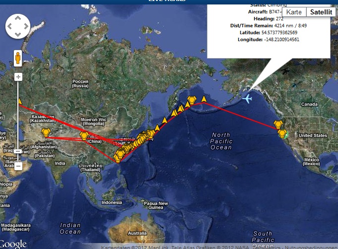
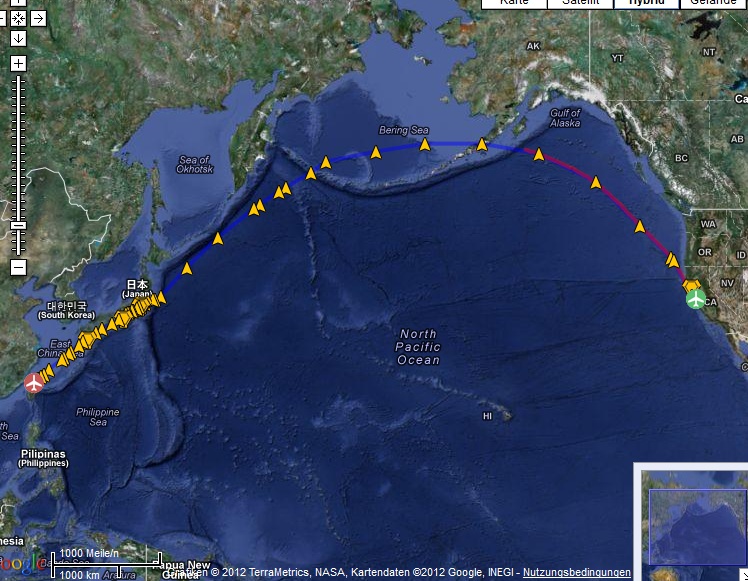
Am I really the only one who tries to use actual AIRAC`s and is looking for a nicer route display on the maps? The navdata coming with phpVMS is way outdated and has many errors. I think that is really something we have to look into. I think displays like that example below will not impress my website visitors very much. I would do it myself if someone could tell me where i can get the data in the correct format. I really don`t know how to approach a update of my navdata. I`m ready to pay any amount for getting that fixed. So please if anyone has ideas reply to that thread or PM me. Edit: I already tried to update it manually with actual AIRAC data and that worked so far but it didn`t show the waypoints on the airway. Only the Waypoints added in the FPLN directly,... but not the points on the airway between them. I had the airways and the sequence in the database....so something was wrong with that approach. That is the excat same rout as above but on vataware....

-
wow amazing kyle thank you sooo much hehe
-
hey guys, what is the easiest way to update my navdata table with the latest AIRAC? As we are updating our routes regulary we also would need the actual airac cycle database to show the routes correctly? I don`t mind paying for it because i know that it costs money getting the AIRAC`s so would be great to get some help here. kind regards Manuel EDIT: secondly...is there a way to display the waypoints in the pilot briefing like
-
I'm afraid you won't get it for free.